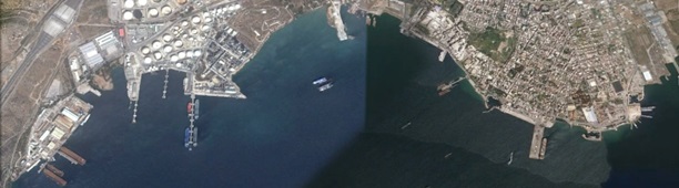
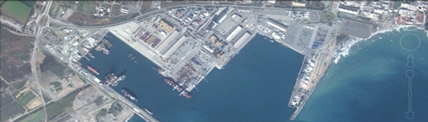
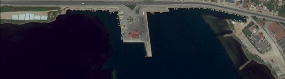
Old Commercial Port offering a 180-meter quay which can accommodate vessels with drafts up to 6.80 meters. General cargo and bulk cargo are the main cargoes handled.
Read More…
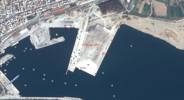
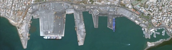
New Commercial (Container) Terminal
Terminal Security: There is an approved Evaluation and Port Facility Security Plan for the Alexandroupolis Port, according to the requirements of the international ISPS Code Required Pilots i.e. sea, river, harbor: Pilot is available upon request Vessels accomodated: LOLO (500m East Lo/Lo quay, 180m South Lo/Lo-Ro/Ro quay), RORO, other Mobile cranes: 1 mobile crane ( ltm 1500 – cap 500tons), available upon request Forklifts: 1 forklift (5tons), more available upon request
Cargoes:
Self propelled: All described types of loads can be serviced at the container terminal facilities, provided that the necessary machinery is available (agreement with private companies)
Non self propelled
Tracked vehicles
Containers
Static breakbulk
Can tracked vehicles naturally maneuver along the quay and within the terminal grounds
Working Shift Times:
Standard: Mon-Fri 0800/1800 (subject daylight)
Weekend: upon request
Holiday: upon request – not all holidays
Overtime: 100% on tariff
Storage Space:
Uncovered: Total surface of concrete floor container terminal, 11.3hectares (open area). Availability depending on the simultaneous use by other uses.
Access to additional storage space outside the terminal grounds: Access through existing port gates and urban – national road network
Can artificial / temporary perimeters be erected around a storage area inside the terminal with fencing or empty containers stacked 2 high: Yes
DGD/IMDG: Class 1 and Class 5
Allowable classes: Loading and unloading of dangerous goods is allowed in the eastern quay of the terminal and is examined on a case-by-case basis and under the conditions of safety measures described in the national legislation. It is not allowed to store explosives in port area, except for the time required to load them.
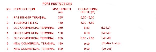
Port Restrctions
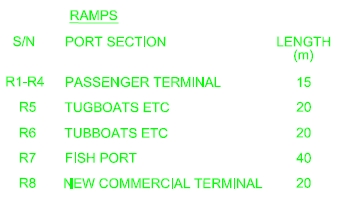
Ramps
Towage: Compulsory for all vessels with GT 1000 and over Fresh water: Available, from shore Bunkering: Available only for trucks Provisions/stores: Available
Eleusis
Latitude / Longitude: 38.03676° / 23.53047°
Eleusis is located on the Saronikos Gulf to the southeast of the mainland, 24 km from Piraeus.
The port operates as a commercial port only, offering a 300-meter quay with 80 meters width which can accommodate vessels with drafts ranging from 5.50 to 8.00 meters. General cargo and scrap iron are the main cargoes handled.
Read More…
Restrictions:
All vessels proceeding to Eleusis Bay have to pass via the Strait of Salamis Channel (Atalante Channel), in daylight hours only, with maximum draught of 10.90 meters, or via the Poros Megaron Channel, with maximum draught of 7.9 meters. In both channels a pilot is compulsory. In addition, tug escorts are compulsory for vessels over 120 meters LOA transiting the Strait of Salamis, with ship lines being used. Under special circumstances and by prior arrangement with the agent and authorities, transit is possible at night – but is very difficult to get permission.
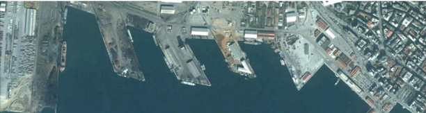
Iraklion
Latitude / Longitude: 35.3475° / 25.1478°
Port has 5 quays with total of 4000 meters length and up to12 meters depth. Commercial Port has 3 quays which can serve the movement of any general or bulk cargo ships (& with pumps or pipes) and containers.
Quay No 3 with total length 959.00 meters and max draft 8.50 meters. Quays No 4-5 with total length 851.00 meters and max draft 12.00 meters. Quay No 6 with total length 380.00 meters and max draft 8.50 meters.
Read More…
Simultaneously, it has an outdoor storage area for the deposition / storage containers, general cargo and covered warehouse packed (pallets, cartons, wooden boxes, packages, bags, etc.) loads. Due to the Customs Service operating within the port, there is the possibility for movement and storage of imported / exported goods.
Pilot Service: Available Tug Service: Compulsory Fresh water/Provisions: Available
Port has facilities for waste disposals such as garbage & liquid wastes.
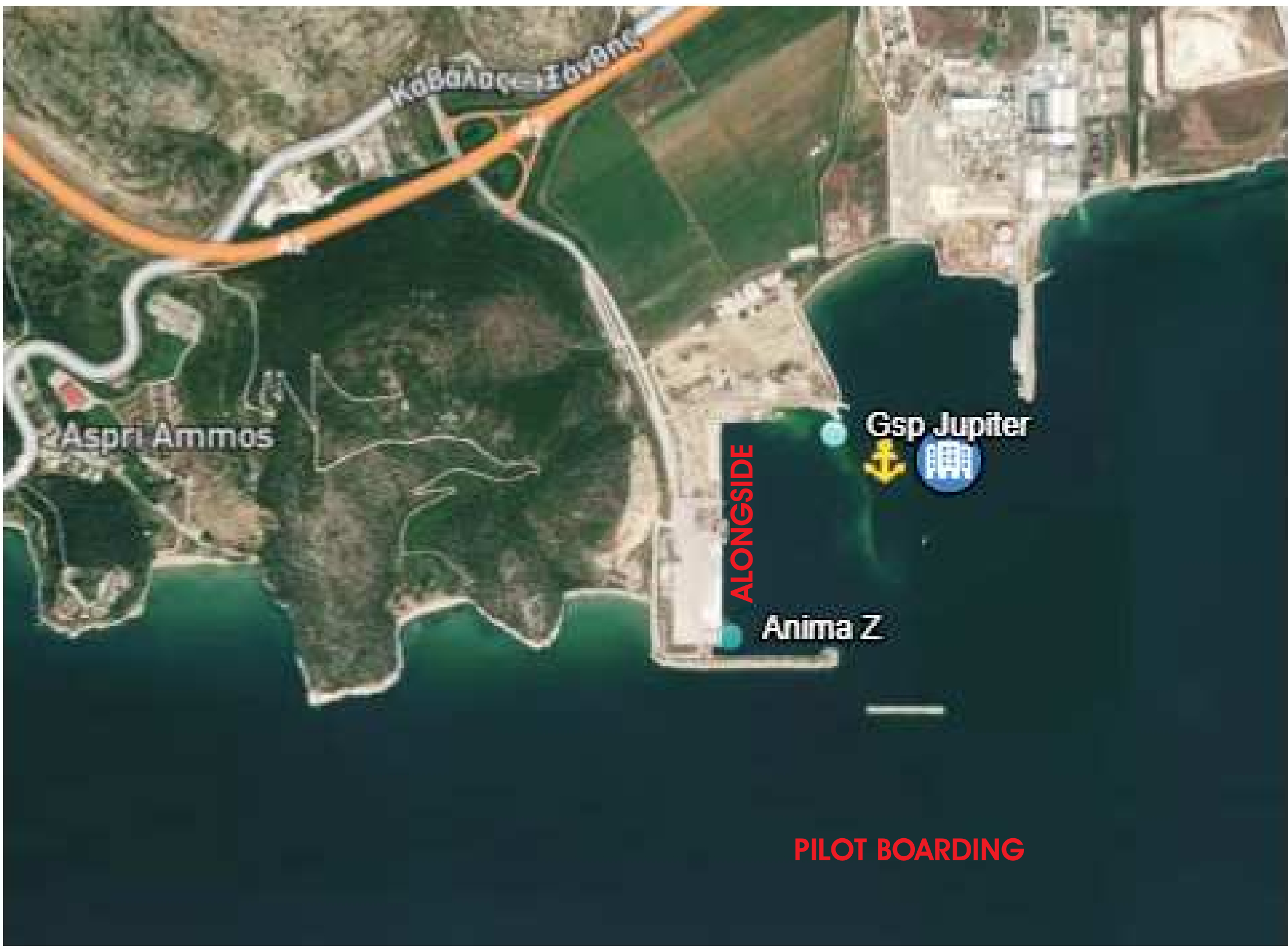
Kavala
Latitude / Longitude: 36.505415° / 23.041845°
Roads / Pilot on board: LA 40 56,1 North – LO 24 28,5 East Port / Alongside: LA 40 56,4 North – LO 24 28,15 East
The commercial port Philippos B’ (Nea Karvali), is located at North Greece, 5 km East of the city of Kavala.
The port of Philippos B’ is directly situated on the North Aegean Sea and hosts one multifunctional single wharf at West with three (3) berths.
Presently only one (1) berth for Loading & Discharging cargoes.
Read More…
1 forklift with lift capacity 40mt
1 forklift with lift capacity 3.5mt
1 GOTTWALD Mobile Harbour Crane HMK 300 E 100t
Loa: 560 meters pier + 40 meters ramp with safe mean draft 10.80 meters Fresh Water: Supply available after berthing Pilot / Tugboat / Garbage: Delivery is compulsory as per port regulations Bunkering: Availability only for trucks (alongside) Provisions/Stores: Available
Lavrion
Latitude / Longitude: 37.70966° / 24.062°
The commercial port has about 680 meters of quays, of which only 300 meters are usually available daily. The commercial quays accept vessels of no more than 120-140 meters LOA and max draught of 8.50 meters. They are mostly used for loading/discharging general cargo, containers (feeder ships) and various non-hazardous dry bulks.
Limassol
Latitude / Longitude: 39.353° / 22.963655°
The port has 5 quays with a total length of 2,070 meters.
Northern Quay with total length 430 meters and max draft 11 meters. Western Quay with total length 770 meters and max draft 16 meters. Eastern Quay with total length 480 meters and max draft 11 meters. Southern Quay with total length 300 meters and max draft 16 meters.
Read More…
There is also a quay on the southern side of the eastern quay with a total length of 40 meters and max draft of 11 meters.
The port also provides covered and open spaces for the storage of cargo.
Fresh water: Available. Provisions: Available.
Nea Moudania
Latitude / Longitude: 40.236955° / 23.281635°
Located on the Thermaikos Gulf.
Port functions as an adjunct of Thessaloniki port. Dry cargo and bulk cargo mainly served at the port. The key length is 210 meters and max draught of 5.70 meters forward and 7.50 meters aft. The port can serve up to two vessels at the same time. Crew changes availabilty.
Read More…
Pilot Service: N/A Tugboat Service: Available Bunkering: Available Fresh water: Available Provisions: Available
Piraeus
Latitude / Longitude: 37.94606° / 23.61377°
Natural port of Athens and Greece’s main gateway.
Loch: No Air draft: Unlimited Tide range, salt or fresh water, density: Tide ±0.5m, Salt water, 6hrs high, 6hrs low Channel water draft: 25.5 meters Tugboat: Compulsory – GRT >1000, 1 TUG COMPULSORY UN/LOCODE: GRPIR Local currency: EURO € Harbour Master office contact (VHF and 24/7 tel): 13 Pilot service: company(ies) and VHF: 12 Security level and contact of PFSO: S1
Read More…
G2 Terminal – Piraeus Car Terminal
Surface area: 145000 m2 Length of platform: 1167 m Depth: 10-11 m Berthing areas: 4 slots Vehicle Storage capacity: 6.700car spots
Activities:
Loading / unloading of cars, H&H and general cargo
Storage until the pick up or loading of the cars
Shifting of cargo on board and through the compound
Selection and segregation of specific VINs at the terminal
Technical support to cargo (battery charge, flat tyres etc.)
Equipment overview
Following the audit that took place in October 2020 by GEFCO 4PL regarding the quality standards & requirements for OPEL/VAUXHALL vehicles, Piraeus Car Terminal’s compound achieved a level of “Excellent” (96%).
Stavros
Latitude / Longitude: 40.668° / 23.7005°
Stavros is located on the Strymonian Gulf.
Port operates as a commercial port, offering a 215-meter quay, 2 berths, North berth with 108.00 meters length and South with 107.00 meters length. North May accommodate vessels with draft up to 8.00 meters and South up to 5.00 meters. Mainly general cargo handled. No crew changes availability at port.
Read More…
Bunkering/Fresh water: Available Pilot Service: Available Tugboat Service: N/A
Stylis
Latitude / Longitude: 38.90723° / 22.616655°
Stylida or Stylis Port is situated on the north side of Maliakos Kolpos (Gulf).
A dredged channel of about half a mile leads to the basis of the port. The channel is marked at the outer end by a pair of light buoys and just before entering the basin by flashing beacons.The maximum draft for entering the channel is 5.80 meters.
Stylida Port has one main commercial pier of a total lengh 200 meters with max draft 5.80 meters.
Thessaloniki
Latitude / Longitude: 40.63692° / 22.91859°
CRUDE OIL SEA BERTH
Positioned at 40° 36.9 N – 22° 53.9 E Max summer dwt: 160 KDWT Fully loaded Max Length (LOA): 340 Meters Min Length (LOA): 240 Meters Maximum draft: 57 ft 6 inches (17.53 meters)
The vessel should be equipped with six (6) wires (without tails) having diameter 36-40 mm and length not less than 240 meters ,mounted on winches.
HELPE PRODUCTS SEA BERTH
Positioned at 40° 37.8 N – 22° 53.6 E Max summer dwt: 50 KDWT Max Length (LOA): 240 meters Min Length (LOA): 170 meters Maximum draft: 42 ft (12.8 meters)
The vessel should be equipped with two (2) wires (without tails) and 9 ropes having diameter 32-36mm and length not less than 240 meters mounted on winches.
Read More…
HELPE BREASTING ISLAND
Positioned at 40° 38.1 N – 22° 53.4 E
The Breasting Island consists of a main concrete platform sized 46 meters X 18 meters.
There are 2 berths one at each side of the concrete platform, the NW side (called Inshore) and SE side (called Offshore). Max summer dwt: 6000 INSIDE SHORE – 22000 OFFSHORE SHORE Max Length (LOA): 110 meters INSIDE SHORE – 170 meters OFFSHORE SHORE Maximum draft: 29 ft (8.84 meters) INSIDE SHORE – 32 ft (9.75 meters) OFFSHORE SHORE
MAMIDOIL JETOIL INNER SEA BERTH (OLD)
Positioned at 40° 39.0 N – 22° 53.1 E Max Length (LOA): 200 meters Maximum draft: 32.05 ft (9.77 meters)
The vessel should be equipped with six or eight nylon ropes with length no less than 150 meters.
MAMIDOIL JETOIL OUTER SEA BERTH (NEW)
Positioned at 40° 37.75 N – 22° 53.22 E Max Length (LOA): 290 meters Min Length (LOA): 130 meters Maximum draft: 46.05 ft (14.03 meters)
The vessel should be equipped with twelve nylon ropes with length no less than 180 meters.
YACHTS Thessaloniki Commercial Port Quay No.3: Length 200 meters, Draft 7 meters Fresh water: Available Waste disposal: Available
Distance to airport about 20 km
Downtown is in a walking distance.All services available.
Suitable for Megayachts.
Thessaloniki Marina (Aretsou)
Positioned at 40° 34.50 N – 22° 56.50 E Max Length (LOA): 40 meters Max Draft: 3 meters Fresh water: Available Electricity: Available Waste disposal: Available
Distance to Thessaloniki International Airport is about 7 km.
Distance to downtown is about 7 km.
Marina Port Carras
Positioned at 40° 04.08 N – 23° 47.05 E Max Length (LOA): 55 meters Max Draft: 5.50 meters Fresh water: Available Electricity: Available Bunker: Available Waste disposal: Available
Distance to Thessaloniki International Airport is about 120 km.
Marina Sani Resort
Positioned at 40° 05.846 N – 23° 18.374 E Max Length (LOA): 26 meters Max Draft: 3 meters Fresh water: Available Electricity: Available Bunker: Available Waste disposal: Available
Distance to Thessaloniki International Airport is abt 70 km.
CONTAINER VESSELS Thessaloniki Container Terminal Quay No.26 – Length: 550 meters, Width: 340 meters, Max Depth: 11.20 meters
The quay is located in the western part of pier 6.
REEFER VESSELS Thessaloniki Commercial Port
Suitable quays for berth are the following: Quay No. 15: Length 175 meters, Depth 9.00 meters Quay No. 23: Length 184 meters, Depth 8.10 meters
Private fridge warehouse facilities close to the pier.
RORO VESSELS Thessaloniki Commercial Port
Suitable quays for berth are the following: Quay No.21: Length 185 meters, Depth 11.20 meters Quay No.23: Length 184 meters, Depth 8.10 meters
Both mainly used for Med Moor.
BREAKBULK VESSELS Thessaloniki Commercial Port
Suitable quays for berth are the following: Quay No.17: Length 190 meters, Depth 10.30 meters, 2 cranes Ardelt Kranitch X 112 Tons at 11 mts Quay No.18: Length 320 meters, Depth 9.10 meters, 2 cranes X 6 mts capacity Quay No.20: Length 350 meters, Depth 8.90 meters, 1 crane X 15 mts and 2 X 25 mts capacity> Quay No.21: Length 185 meters, Depth 11.20 meters, no cranes Quay No.22: Length 370 meters, Depth 8.50 meters, 3 cranes X 10 mts and 1 X 25 mts capacity Quay No.23: Length 184 meters, Depth 8.10 meters, 3 cranes X 6 mts capacity Quay No.24: Length 635 meters, Depth 11.20 meters, 2 cranes X 35 mts and 4 X 40 mts
GENERAL CARGO Thessaloniki Commercial Port
Suitable quays for berth are the following: Quay No.15: Length: 175 meters, Depth: 9.00 meters, 2 shore cranes X 3 mts capacity Quay No.17: Length 190 meters, Depth 10.30 meters, 2 cranes Ardelt Kranitch X 112 Tons at 11 mts Quay No.18: Length 320 meters, Depth 9.10 meters, 2 cranes X 6 mts capacity Quay No.20: Length 350 meters, Depth 8.90 meters, 1 crane X 15 mts and 2 X 25 mts capacity Quay No.21: Length 185 meters, Depth 11.20 meters, no cranes Quay No.22: Length 370 meters, Depth 8.50 meters, 3 cranes X 10 mts and 1 X 25 mts capacity Quay No.23: Length 184 meters, Depth 8.10 meters, 3 cranes X 6 mts capacity Quay No.24: Length 635 meters, Depth 11.20 meters, 2 cranes X 35 mts and 4 X 40 mts capacity
HEAVY LIFT VESSELS Thessaloniki Commercial Port
Suitable quays for berth are the following: Quay No.17: Length 190 meters, Depth 10.30 meters, 2 cranes Ardelt Kranitch X 112 Tons at 11 mts Quay No.18: Length 320 meters, Depth 9.10 meters, 2 cranes X 6 mts capacity Quay No.20: Length 350 meters, Depth 8.90 meters, 1 crane X 15 mts and 2 X 25 mts capacity Quay No.21: Length 185 meters, Depth 11.20 meters, no cranes Quay No.22: Length 370 meters, Depth 8.50 meters, 3 cranes X 10 mts and 1 X 25 mts capacity Quay No.23: Length 184 meters, Depth 8.10 meters, 3 cranes X 6 mts capacity Quay No.24: Length 635 meters, Depth 11.20 meters, 2 cranes X 35 mts and 4 X 40 mts capacity
NAVAL SHIPS Thessaloniki Commercial Port
Suitable quays for berth are the following: Quay No.2: Length 90 meters, Depth 7 meters Quay No.3: Length 200 meters, Depth 7 meters Quay No.4,5,6,7: Length 400 meters, Depth 7 meters
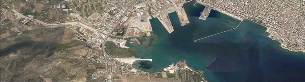
Volos
Latitude / Longitude: 34.65841° / 33.0271°
Volos port is located on the head of the Gulf of Pagasitikos on the eastern Greek mainland. It’s anchorage area is situated about 2 km from the port entrance. Two jetties can accommodate commercial vessels.
Jetty B
It is the jetty located in the middle of the port. East side with length 400m end max draft 9.50m. It is provided with two shore cranes: Rocas No 8 capacity 25 metric tons, and
Rocas No 9 capacity 40 metric tons, which move up to rails for loading and unloading. West side with length 300m and max draft 9.20 m used for cruise vessels, and when it is free used
for loading and unloading by using external mobile crane or vessel’s cranes.
Read More…
Jetty A
It is located east of jetty B. East side its length is 300m and max draft 9.50m. Jetty A is used for loading and unloading by using external mobile crane or vessel’s cranes. At the jetty head length 150m and max draft 9.50m. There are 2 shore cranes which move up to rails, capacity 6 tons each. West side with length 300m and max draft 9.50m., used for unloading steel scraps.
Towage: Compulsory for all vessels with GT 1000 and over Fresh water: Available, from shore Bunkering: Available only for trucks Provisions/stores: Available
We are using cookies to enhance your user experience. By continuing to browse this website you accept the use of cookies. AcceptRead More